First Alert Weather Day Thursday: Late-Day Severe Storm Potential Raises Wind, Hail, and Tornado Concerns
Late-day storm window could bring damaging weather to Northeast Ohio
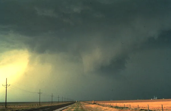
A “First Alert Weather Day” designation is in effect for Thursday as forecasters track the potential for thunderstorms that could intensify late in the day and into the evening across Northeast Ohio. The primary concern is a narrow window in which storms could organize quickly, producing isolated damaging wind gusts, with a secondary risk of hail and a brief tornado.
The expected setup centers on a warm, humid air mass advancing into the region ahead of an approaching cold front. That pattern can increase atmospheric instability and, if it coincides with strong winds aloft, support thunderstorms capable of meeting severe criteria. The timing matters: a later-day arrival may allow daytime heating to boost storm intensity, while earlier clouds and showers could limit how much the atmosphere can “recharge” before the main line arrives.
What “severe” means and why timing remains uncertain
In practical terms, severe thunderstorms are defined by hazards that can damage property and endanger people outdoors or in vehicles. The most common severe hazard in Ohio is straight-line wind, which can down trees and power lines and create localized power outages. Hail can damage vehicles and roofs, and brief tornadoes can occur even in events where wind is the dominant threat.
Forecast confidence often hinges on storm evolution earlier in the day. If morning showers and storms move through and linger, they can stabilize the atmosphere and reduce the later severe threat. If there is a break in precipitation and skies brighten, conditions may become favorable for stronger storms later in the afternoon and evening.
Key impacts residents should plan for
Damaging wind gusts: the most likely severe hazard, capable of bringing down limbs and causing sporadic power outages.
Heavy downpours: brief, intense rainfall can reduce visibility quickly and lead to localized ponding on roads.
Hail and a brief tornado: lower-probability threats that remain possible in the strongest storms.
Storms that arrive after dark can be harder to track by sight, increasing the importance of receiving timely weather alerts.
How to prepare without overreacting
Residents planning evening travel, school or sports activities, or outdoor work should build in flexibility. Charge phones and keep multiple ways to receive warnings. If thunderstorms approach, move indoors away from windows and avoid sheltering under trees. Drivers should be prepared for sudden wind gusts and sharply reduced visibility in downpours.
Conditions will be refined as higher-resolution guidance and real-time observations clarify whether storms become widespread or remain isolated. The First Alert Weather Day is intended to heighten awareness during a short timeframe when impacts can escalate quickly.